|
Berkshire Photos by Jan & Christy Butler
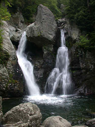
Bash Bish Falls State Park (250K/320K) |
||||||||||||||
| Even in February, Bash Bish Falls is very accessible. Plowed roads and usually someone has already beaten a path in the snow before you. Just watch for slippery rocks and dress warm. During the summer months attendance to the falls does increase making Bash Bish Falls one of the most visited falls in Massachusetts, although no reservations are needed.
|
||||||||||||||
|
The legend of Bash Bish Falls centers on a beautiful Native American Indian maiden named "Bash Bish" who is jealously accused of adultery. The chief of the tribe deems that the "Great Spirit" will pass judgement and punish her. So, Bash Bish was set adrift in or strapped to her canoe. Just prior to her careening over the edge of the falls a halo or shaft of sunlight with birds and butterflies formed above her head. The tribe finds the shattered wreckage of the canoe in the pool below, but never her body. To this day, if you listen closely to the rhythm of the falls, you'll hear the falling waters repetitively whisper her name a reminder of her innocence and beauty. The image of Bash Bish is often seen in photographic images of the falls. (see photo below)
Another spectacular sight located directly above the falls is Bash Bish Gorge. With its sheer 190 foot cliffs, it's an impressive sight created by the glacial forces and thousands of years of erosion by Bash Bish stream. However, many accidents resulting in serious injury or death have occurred. Hence, contemporary local lore on how Bash Bish Falls received its name. Inquisitive tourists who venture close to the edge for a better view, slip into the gorge and go BASH!...BISH! striking bottom. The same goes for those who dive into the inviting pools beneath the falls and downstream, only to BASH or BISH into the many unseen rocks and ledges. The gorge area is now barricaded by posts and cable for safety. A hiking trail does traverse the southeast side of the gorge. While very steep, it is accessible by forging Bash Bish stream using the large rocks just beneath the falls or above crossing the stream just as it enters into the gorge up stream. Either way you'll have to make both crossings to return to the upper parking area if you select this as a circular route. ( Hiking boots or sneakers with cleated soles are strongly recommended over sandals.) In addition, the melting of seasonal spring run-off or recent heavy rains can make crossing the stream hazardous or impossible. |
||||||||||||||
|
GPS Coordinates
42° 06' 056'' N 073° 29' 038'' W Elevation 80 ' Plunge 1014 ft. above sea level ACCESS Easy public access. Moderate hiking on woodland trails to strenuous . Swimming not authorized . |
||||||||||||||
 |
||||||||||||||
| Do you see the image of indian maiden Bash Bish within the Falls?
|
||||||||||||||